SailTimer
for Google Maps
This is a free
demo, in which you can enter details like wind direction and see SailTimer
calculate optimal tacking routes, right in your web browser. Google
Maps has some limitations: it requires an internet connection, and
has no hydrographic depth data. But you don't need to download or install
anything, and you can plot your optimal tacking route on aerial photos of your
favorite sailing area.
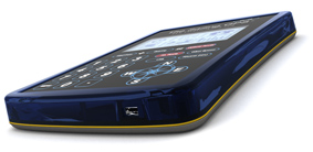
The Sailing
GPS
(tm)
This is a portable
handheld electronic device that continuously updates optimal tacking routes and Tacking
Time to Destination (tm). There is nothing else
like it. Submersible. Daylight-viewable. Also works like a GPS antenna with your computer: just plug in a USB cable or use the wireless Bluetooth,
to share GPS data with electronic navigation chart programs
or Google Earth. Use it
on its own at your helm with the computer safe down at the nav station, or take it dinghy
sailing.
|
The
Original SailTimer
(tm)
This is the Windows program that first allowed you to plot the
optimal tacking route and calculate the Tacking Time to Destination (tm).
Will also compare the TTD for your current route
to the optimal route. Download the free trial ($14.99 upgrade to use without an internet connection). This starter version uses only a basic polar plot and cannot display hydrographic charts. (For that,
you'll need one of the programs below.)
Electronic
Navigation Chart Programs for Computer
Maybe you have a computer onboard for email
and watching movies already. That also gives you full multimedia capabilities
for a navigation system and interactive cruising guides. There is no
extra hardware cost with electronic navigational chart (ENC) software:
order the software online and use NOAA's free hydrographic charts for US waters. SailTimer has been licensed for integration
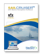
into the marine navigation software including NavSim
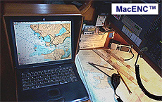
(Windows) and MacENC
(Mac). No other GPS products display Tacking Time to Destination and optimal tacking routes overlaid on a chart.
Home | Background | How
to Use | Media |
Implementations | Technical | Corporate | Contact
Us

Copyright 2005-2011 (c) SailTimer Inc.
|