|
|
|
Click
here to try SailTimer on an aerial view of your favorite sailing
grounds, You can drag the
map around or use the controls at the upper left. |
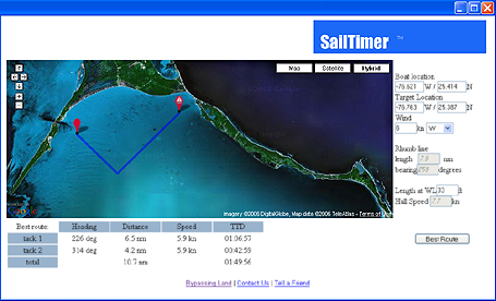
SailTimer for Google Maps Plot your optimal tacking routes on Google Maps online. View a satellite photo, a road map or a hybrid of the two. Zoom way in. Move around and check out a new gunkholing location. SailTimer for Google Maps runs in your web browser on Windows and Mac. **Note: It is no longer available, because of the newer features and better precision available in The Sailing GPS handheld, the iPhone app, and in the full chartplotter programs from MacENC and NavSim. In the screenshot at left, optimal tacking from SailTimer is being plotted on Google Maps. There is no hydrographic depth data with Google Maps, and Google Maps only works with an online internet connection. But this gives you a chance to test out SailTimer with real maps of your favorite sailing location. CLICK
HERE to try it out. (No longer active.) SailTimer is also integrated in the full GPS chartplotter systems from NavSim
and MacENC, which you can also find on our Products page (Choose
Your Version). Use one of these if
you want your tacking route overlaid on charts with water depths,
or to use more accurate polar plots and multiple wind speeds.
Home | How
to Use | FAQ | Media | Newsletter 
Copyright 2005-2011 (c) SailTimer Inc. |